Fáilte
Seafield Summary
PARISH OF KILMURRY IBRICKANE
TOWNLAND OF SEAFIELD
This project is dedicated to Michael Falsey.
Direct links to the various Primary Historical documents in these pages HERE
Introduction – The evolution of townlands.
Townlands are the smallest administrative unit of Irish local government. The network of townlands, as it now stands was laid out in the first half of the 19th century. The Boundary Survey commenced work in 1824, marking out, on the ground, where necessary, the actual boundaries of every townland. Where they felt it necessary, they subdivided and/or re-arranged, the pre-existing land divisions, to create smaller units. The Ordnance Survey built on the work of the Boundary Commission to produce maps of the entire country at a scale of 6” to the statute mile. This was done in County Clare during the 1830s and the process gave formal definition to the townland structure of Clare.
As part of their work the Ordnance Survey carried out an extensive documentary and field survey of placenames and recorded the results of their work in Field Name Books. Some, but not necessarily all of the names recorded in the Field Name Books were incorporated in the subsequent maps. The Ordnance Survey set down definitive names for each townland and also for other features entered in the Name Books, these were signed with the initials J oD, presumably for John O Donovan, although not all of the initials were by the same hand. The information collected during the 1830s was first published in map of 1842
Prior to the development of the townland system the lands of Ibrickane Barony were denominated in ‘quarters’ and the earliest known list of these quarters is from a survey of the O Brien estates by Henry Illsworth in 1615 in which he lists 63 quarters and gives the names of the immediate lessors. Further surveys of Ibrickane by the O Brien Estates always accounted for approximately the same number of quarters. In the early surveys Seafield was not listed as a land division in its own right – It was part of the ‘quarter’ of Tromra or sometimes, Tromra Castle, under the name Carrownacruss or Barnagruss..
In all, for the barony of Ibrickane, the Ordnance Survey created 110 townlands (counting Mutton Island as one) from the earlier 63 quarters, which comprised the Barony of Ibrickane. Thus Kilfarboy has 40 townlands, Kilmurry Ibrickane 51 (including Mutton Island) and Killard 19.
For a comparison of the O.S. maps Click here
Early maps.
Prior to the Ordnance Survey map of 1842, Seafield rarely appeared on maps and on the few occasions when it did, it was Seafield House that was shown. The pre O.S maps that I have located are:
Moland's map, 1703
Pelhams map, 1787
Sydney Hall 1830
John Arrowsmith 1844
Seafield and Mutton Is. Nautical Chart 1850
O.S. Fair Plan, 1840
Placenames.
For the purposes of this project we will be considering placenames within the townland of Seafield, as derived from four sources
1. The Ordnance Survey Name Books (see above).
2. Names provided by Michael Falsey, in interviews with Donal De Barra in September and October 2007.
3. Names mentioned in two court cases involving the townland of Seafield in the 19th century:
a). The Wren Boy murder case of 1827.
b). Brew v Haren 1873
4. An excellent placenames project by Quilty National School, in which the children, under the direction of their teacher, Michael Carrick, collected and mapped the placenames of their locality.
In the script below, placenames are spelled as they appear on the Ordinance Survey maps. If the name does not figure on any map I have given it a phonetic English name, while still trying to preserve the original structure of Irish words. Most of the general information and comment, below, is from Michael Falsey, unless otherwise indicated.
1. Seafield is a small townland at the Western mainland, extremity of Kilmurry Ibrickane parish, (Mutton Island is, of course an even more Westerly townland of the parish). Seafield, together with Mutton Island form the southern delineation of Mal Bay (although maps sometimes show Mal Bay as stretching as far West as Loop Head). It is notable that Mutton Island and Seafield are the only two townlands in the parish with names that are, essentially, in English, as opposed to Anglicised Irish words and even then Mutton Island is clearly a putative translation of ‘Inis Caorach’.
Seafield, as a townland in its own right, was created by the Boundary Commission who, presumably, felt that the townland of Tromra was too big and needed to be subdivided. ‘Tromra (of the) Castle’ had already been given an existence of its own in some previous land surveys but the Boundary Commission created two further subdivisions, so that in all they ended up with:
Tromra West,
Tromra Middle
Tromra of the Castle and
Seafield.
Pairc Na Mara in recent attempts to beautify the area!
2. Baurnagross - [Barr na gCros, Height of the Crosses], is often considered to be the ‘proper’ Irish for Seafield, instead of Gort / Pairc na Mara and it is patently an older name for the area, even though the exact bounds of that area cannot be delineated. It is shown on all the Ordnance Survey maps as a subdivision of the townland located in the most easterly part.
The earliest reference that I have found to this name is to another variant of it i.e. ‘ Carrownagruss’ (Ceathrú na gCros, the Quarter of the Crosses,) which is referred to in the Book of Survey and Distribution (1638 ?) as, apparently, a subdivision of ‘Trumree of ye castle ‘
The usual explanation given for the name, Baurnagross is that sometimes when residents of Mutton Island died on the mainland, there might be difficulty transporting the remains back for burial on the island due to bad weather. The coffins were then temporarily buried on the mainland pending improved weather conditions and the spot marked by a temporary cross. There is no particular time period attaching to this explanation.
The question arises as to whether there ever was an actual burial ground on the island, as there is now no visual evidence for such, and there are headstones in Kilmurry Graveyard commemorating people who lived on the island and whom it might be expected would be buried in an island graveyard if there was one. The O.S. maps show Baurnagruss as being the most easterly part of Seafield townland, but if coffins were awaiting trans-shipment to the island they would, presumably have been brought as far as the Cuoneen, where excavation of a temporary grave, in the sand would have been very easy?
The early Ordnance Survey maps show a burial ground on the island, but perhaps the map-makers were relying on the same legends that prevail today.
The remains of an old monastic cell were seen on the island, by Westropp around the beginning of the 20th century- “It has a rude stone shaft of a cross, part of the west gable of an oratory of St. Senan …. ” and the remains of the Matthew Kenny stated in evidence that there were only two houses on the island.)
Of course a tragic event, such as a boating accident, whether it involved islanders, the Spanish Armada or commercial shipping, could provide an obvious reason for the erection of crosses but no particular event has been identified, in his context The point indicated for Barrnagruss on the Ordinance Survey map of 1842 is not at the Point at all, but near the eastern boundary of the town land.
There is one other matter that may have a bearing on the meaning of ‘Barrnagruss’ but its significance is not as clear as one might wish. The O.S Namebook identifies a fort in Seafield called Lissnagruss [Lios na gCrois , the Fort of the Crosses], but this does not appear on the ensuing map of 1842.
A fort called ‘White Point Fort’, appears only on the maps of 1912 and 1920 and this later is perplexing because its alter ego ‘Rinnbaun Fort’ [- Rinn Bán, White Point], is shown just across the bay in the townland of Emlagh.
The Fair Plans, 1840 show a fort called Pounthabawn [Pointe Ban, White Point], but located now in the townland of Trumroe [sic] Castle. The relative positions of the three ‘White Point Forts’ is shown on this map.
It is tempting to suggest that the fort in Seafield townland is incorrectly named as White Point Fort by the Ordnance Survey and should in fact be named Lissnagruss [Lios na gCrois , the Fort of the Crosses]. If this were so, the possibility arises that the reference to ‘Crosses’ dates to the period of earthen forts and lisses – 700-1000 A.D. This brings us to the era when Mutton Island was devastated by the equivalent of a modern-day tsunami. It is recorded in both the Annals of the Four Masters and the Annals of Clonmacnoise that there was an earthquake-type event in the year A.D. 800 (or 801), which broke Mutton Island into three parts, Such a cataclysmic event might well have given rise to the Crosses on the mainland, where it is recorded that 1010 people died.
The argument is also made that White Point Fort in Seafield is named after the White family who in later time were known to have occupied Clonmore Lodge, but this may be just coincidence – the Irish name for the ‘Point of the Fort of White Family’ would be Rinn Dun De Faoite or Dún an Fhaoitigh, which would, in turn, have been Anglicised ‘Doon an Eat’ or some such, rather than Rinnbaun. Regardless of the value of the foregoing thoughts, there is no further clarification of the references to cross or crosses.
Michael Falsey is, I believe, aware of the difficulties with the usual explanation of the name Barrnagruss, and he offered no specific location for it.
Pronunciation – Baurnagruss
3. Site of Armada Wreck. This point is indicated by the Ordinance Survey as the site of the wreck, in 1588 of the Spanish Armada ship – San Marcos. Some people would dispute the actual site, the suggestion being that the ship actually grounded on the next headland to the North, which is now named Spanish Point after the event.
Photo showing relative positions on Lurga Point
4. Thone a Vile – [Tón a Phoill, the Bottom of a Hole, the Ocean Bottom]. The phrase is used regularly in Irish in reference to the sinking of a ship and in this case most likely refers to the sinking of the Spanish Armada ship San Marcos at this point, in 1588.(see 3 above)
Location map for No. 4. Thone a Vile
Photo -Tonnafaill.
Photo relative-positions-on-the-Lurga
Pronunciation
5. Lurga – [Lorga, a shin], from looking at the map, up-side-down, it might be observed that the townland has some resemblance to a foot and shin, this, however, is not readily observable on the ground and the name existed long before the local people saw the maps. The word Lorg pl. Luirg also means a track or trace and given that this is the start of the track to the island, which only emerges at low water of a Spring tide, it seems more likely that Lorga is a colloquial plural of this. The Field Name Books comments “Lurga, shins, a strand from which there is a road leading to Mutton Island. Said to be made by clergy some time ago, residing therein for the accommodation of people interred in this island” by which they seem to prefer the ‘shins’ explanation. Their second comment, to the effect that the causeway was constructed by human agency is hardly sustainable. The causeway is not sandy but of seaweed covered stones (mostly about football size) which are very difficult to traverse, nor is it continuos all the way to the island, it is transected by a water channel, which is still deep enough for a boat to cross it, even at lowest tide. The general plan of the causeway can be seen on the Nautical Chart.
The extremity of the Lurga is credited as being the point where the Spanish Armada ship was lost, in 1588 and this is indicated on the O.S. 6" Map O.S. 6” Map.
Lurga is often referred to simply as The Point or Seafield Point.
Location map for No. 5. Lurga Point
Photo - Lurga
Photo, relative positions on the Lurga.
Pronunciation
6. Mal Rock and Maolawn. This is marked on the O.S. 6" map but there is no specific rock, now known as such to the local people, nor is there any rock that is particularly conspicuous, but some such may have existed and been accounted for by coastal erosion. The reference in the namebook is to Maul [– Meall, a lump, etc] There is, however a reef nearby, exposed only at low tide, called the Maolawn and Mal Rock may be intended as a translation of this. There is plenty of scope here though, for confusion because there are three other names in the same general area –
Log a Maolawn and
Lackaweelaun which is also sometimes called Carraig a Veidhlin.
The pronunciation of the second element of all these names in Irish is similar and all could have been ‘translated’ to Mal in English. It is unlikely that the story can be unravelled, satisfactorily.
Photo, relative positions on the Lurga
The legend of Cuchullan and Mal is the customary origin legend for Mal Bay. In preparing the first O. S. map the mapmakers would have been familiar with the legend and on the lookout for any particular points of reference to it. Although it is not recorded in the O.S. Namebook, unless we identify Maul with Maolawn, it does seem likely that they encountered the Maolawn and, identifying it with Mal, entered it on the map as ‘Mal Rock’ The location on the O. S. map is not identical with, but very close to the point identified by Michael Falsey as Maolawn.
In the Calendar of State Papers there is a reference to “ Idulculchy, Fumaneyn, Ydoonmal, Treanmanagh, Tromrach,two islands of the sea Iniskerach and Inismatail as formerly granted by Donchad Cairbreach O Brien”
It is possible that the second element of the name ‘Ydoonmal’ is identifiable with the Mal of Malbay and this might suggest that the name Mal referred to an area of land at that time. Unfortunately it is not possible to be more specific at this time.
Location map for no. 6 Mal Rock and the Maolawn
Photo, relative positions on the Lurga
Pronunciation, The Maolawn.
8. Logh na Maolawn – [Loch an Mhaoláin, the Lake of the Small Bald (Rock)]. This is a small body of water between the Maolawn and the main body of rock, all of which is covered at full tide. It is notable that the Irish word Loch, a lake or pool continues in use in the English of this area, in the form log. Thus a pot-holed road might be referred to as having ‘logs of water’.
Location map for no. 7 Log a Maolawn
Photo, relative positions on the Lurga
Seals passing through Log na Maolawn.
9. Lacknaweelaun – [Leac na bhFaoileann, Flagstone of the Seagulls], unlikely though it may seem this name is probably a synonym for Carrickaveidhleen [Carraig a Veidhlín, rock of the fiddles or violins]. The words Carraig and Leac are synonymous and as explained at 6 above the three words faoileann, veidhlin and maolaun, with the M aspirated in the latter, would all have similar pronunciation in Irish, in these contexts.
Carrickaveidhlin is sometimes said to be a name of a rock on Mutton Island, which is shaped like a fiddle, but none such can now be identified.
The Schools Folklore Collection adds a further twist to the story with “Tonn na bhFidil. - The sea surrounded by rocks near Mutton Island is shaped like the bottom of a violin and that is how it got its name”.
10. The Cuoneen [- Cuainín, small harbour]. This has always been an important little bay for the canoe fishermen. Before the pier was first built in 1822 it was probably the prime launching point for boats. When the pier was built, in its obviously sheltered location, it could not be accessed at low water and so the Couneen continued in use on all other occasions and even after the Barra was cut, in 1845, through the rock to facilitate access to the pier, at lower tides, Northerly winds could still render the Cuoneen a preferable launching point. The numerous references to the Cuoneen in the proceedings in Brew v Haren emphasise the importance attached to the location, at that time. Incidentally, it has been suggested by some sources that Brew’s used to levy a charge on fishermen for use of the right-of-way to launch their canoes but this is not supported by the proceedings of the court case as reported.
Location map for no. 10, the Cuoneen
Photo, the Cuoneen, from above
Photo 2, the Cuoneen
11. The Purt Bwee [- Port Buí, Yellow Bank], This name for the bank above the Cuoneen, seemed particularly appropriate on the evening the photo was taken. This location is also simply and commonly called ‘The Point’, ‘Lurga Point’ and ‘Seafield Point’.
Photo, the Purt Bwee
Location map for no 11 the Purt Bwee
12. Poul Gurm [-Poll Gorm, Blue Hole] This is a common name around the Irish coast, where similar deep holes of blue seawater are common. In this case the spot is located close to the harbour mouth. In the early 20th century, a concrete dam was built between the two sides in order to retain the waters of the high tides. A small pump was then used to pump the water up to the fish station, where mackerel were gutted and cleaned, prior to being salted and packed for export.
Location map for no. 12, Poul Gurm
Pronunciation - Poul Gurm
Photo Poul Gurm
13. Poul Dine [Poll Doimhin, Deep Hole or Pool]. As with no. 12 the placename Poul Dine is common around the Irish Coast to describe a common feature.
Location map for no. 13, Poul Dine
Pronunciation - Poul Dine
14. Cool a Kay [– Cúl a Ché, the Back of the Quay], The name refers to the rocky area at the back of the old quay or pier.
Location map for Cool a Kay
Photo - Cool a Kay
Pronunciation
15. The Borra. - A number of explanations are possible, none totally convincing. Michael Falsey, who provided the name, felt it might relate to the cutting of the rock which was done to enable access to the quay at low tides, from the Irish bearradh, act of shaving clipping etc. The name might also refer to barra, a bar. In nautical terms a bar may refer to a sand bar obstructing access to a harbour, and perhaps such a bar materialised, even temporarily, after the blasting to create access through the Gabhalach at low tide. A bar might also refer to a device used in ports to measure tide levels – as in the phrase “high tide at Dublin bar”. A detailed history of the construction of Seafield Pier might disclose the existence of such a device.
Location map for No. 15 - The Borra
Pronunciation, The Borra
Photo - The Borra (note that this photo shows the new pier extension, which is a very recent addition)
16. The Lickeeny [- Licíní, Small flagstones]. The North-western extremity of the rocks which constitute the Borra. Both the Lickeeny More and Lickeeny Beg are almost always under water, except at the lowest tide. For the local fishermen, the procedure for avoiding damage to boats by the Lickeeny is to turn Westwards only after crossing (an imaginary) line from Jones House to Goulin a Kay (Gualainn an Ché, the shoulder of the Quay)
Location map for No. 16 - the Lickeeny
Photo - The Lickeeny
Pronunciation, The Lickeeny
19. The Quay This is shown as “M.P. PIER” on the 1912 map, Probably the abbreviation is for ‘ multi-purpose’. In addition to fishing and pleasure uses the Quay had a substantial use for small-scale commercial shipping which brought supplies for local merchants. The initial pier was built in 1822 but because access to it from the sea was by rounding the Sharra Fean (No. 26 below), it could not be reached at all at low water. This was rectified in 1845 when the Borradh (No. 15. Above) was cut through the Guwallach to create an access channel. Unfortunately a full history of the Quay cannot be provided at this time.
At the time when there were people living immediately adjacent to the pier, it became an occasional social venue especially, for those awaiting the return of fishermen.
Location map for the Quay
Photo the Quay and other points relative
Chronology of construction and maintenance of the pier
Seafield-Pier-c1973-Causeway
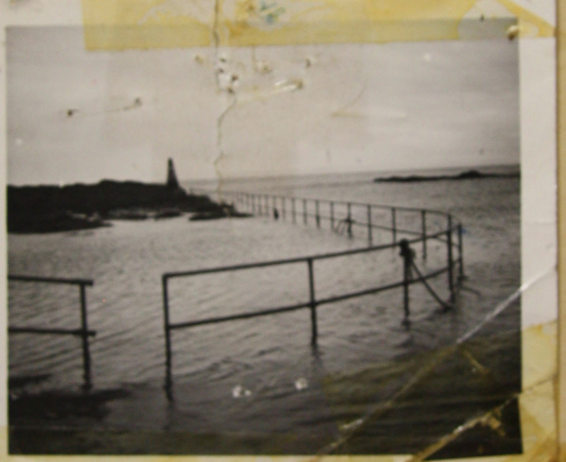
20. The Lighthouse. This was a small lighthouse, About 10 or twelve feet high, on the end of the (old) quay. Its primary purpose was for the guidance of local fishermen when they were out at night. It was not intended for the benefit of mainline shipping. It was demolished in 1984, during renovation work on the pier.
Location map for the Lighthouse
Photo, the Lighthouse
21. The Fish-processing Station. This station prospered around the years of the first world war. It is described by Cora O Grady in her Leon Walking Trail Guide
22. The Boat House. See No. 46 below.
23. The Cottages
24. The Guwallach. [ – Gabhálach, Taking, catching, …… passing or going by. (Dineen)]. This is the place shown on the O.S. maps 1842 and 1920 as Downe’s Rock. I have found no authentication for this later name which is not even mentioned in the Field Name Books. As regards the name Guwallach, the only suggestion I can make is that the word Gabhalach refers to the point of departure (as in Ag gabháil dom siar an bhóthair)
Location map -No. 24, The Gabhalach
Photo - The Gabhalach
Photo The Guwallach relative to other positions
Pronunciation. The Guwallach
25. Downes Rock. This name is given on the O.S. maps but it not known as such, now. See 24 above.
Location Map No 25 Downe's Rock
26. The Sharra Fean [Siorra Fian, Fierce or Wild Reef]. This reef would have been of greater consequence to boatmen before The Borra ( see 15 above) was cut in 1845, because prior to that time boats had to come around the Sharra Fean to access the Quay and this could not be done at low water.
Location map -No. 26, The Sharra Fean
Photo, The Sharra Fean relative to other points.
Pronunciation, The Sharra Fean.
27. The Inner Strand. As opposed to the Back Strand, this faces Eastwards and is often covered in seaweed. Even though it is more sheltered, it is rarely used for bathing.
Location map, No. 27. The Inner Strand
Photo, Cows on the Inner Strand
28. The Dough [ – Dumhach, Sand-hills]. Always referred to as the Dough in previous years, now both ‘Dough’ and ‘Sandhills’ are commonly used.
Location map - No. 28. The Dough
Photo - The Dough (part)
Pronunciation- The Dough
29. Cruack More [– Cruach Mór, the Big Hill]. This is a dry sandhill that was used for spreading seaweed - Kelp - to dry. The dried weed was used to make iodine, as described in the article Quilty Long Ago, which records the reminiscences of John Fennell.
Location map - No 29. Cruach More
Photo, The Cruack More
Pronunciation, The Cruack More
30. Poul na Goneeny [– Poll na gCoinníní, The Hollow of the Rabbits], a hollow beside the Cruack More (no. 29. above).
Location map - Poul na Goneeny (same as Cruack More)
Pronunciation- Poul Na Goneeny
31. The Black Gate. This was the entrance to Brew’s farmyard and haybarn and may be the ‘Seafield gate’ referred to in the Reports of the Downes - Wrenboy Murder case of 1828. It seems to fit the circumstance better than The Gate at No. 36 below.
Location map - The Black Gate
Photo - Site of The Black Gate
32. Tober na Halle, [ – Tobar na hAille], Well of the Cliff. This was a spring well situated near Tonn a Voher (No 33 below). It is no longer in regular use for human consumption.
Location map -No 32, Tober na Halle
Photo – Tober na Halle
Pronunciation, Tober na Halle
33. Thone a Voher / Ceann a Voher [– Tón a’ Bhóthair / Ceann a’ Bhothair, End of the Road / Top of the Road], both names are used locally, as the road is level the question of which is its head and tail is subjective. It is the point where the road from Quilty merges with the strand. Even after the right-of-way to the Quay was established and a County road built, it appears that traffic for the Quay preferred to take the route across the strand, via Thone a Voher at least when the tide permitted.
Location map - No 33, Thone a Voher
Photo - Thone a Voher
Pronunciation
34. Boyles Cross. Where the road from Quilty turns inland (South) just before Thone a Voher.
35. Colloo More and Beg [ – Colbha, an Edge , Ledge. The Big Ledge and the Small Ledge]. Although these are reefs now, most probably they were the cliff faces in earlier times before the soil covering was eroded away by the sea. A significant strip of land existed when the Survey of 1842 was conducted (see The Gate, No. 38 below) and the Colloos were obviously of greater significance to the people when they were only yards from the back door of the cottages.
Location map - No 35, Colloo More and Beg
Photo - Colloo More and-Beg
Pronunciation
36. The Gate . This is clearly a relatively, recently evolved placename but there is still some difficulty with it. The name actually attached to a village of small thatched cottages which were on the sea side of the road. Michael Falsey has made a wonderful painting which shows, the Gate Village, as it stood in his youth – amongst the families that lived in these houses at the time were O Dowds, O Boyles, Harens, and Shannahans, As living standards improved, the families acquired better accommodation locally, the cottages were knocked and the stones taken away for other uses. Coastal erosion has accounted for the land that the cottages stood upon and the photo taken today shows a rather different situation.
The lands of Tromra and hence Seafield were from earliest times, part of the O Brien estates. The records of early ownershiip show that they were sold, along with much of the rest of Ibrickane, in 1745, when Tromra was purchased by John Stackpool. The Burton family leased these lands since ‘the first of James 11’ – 1685 (according to the pleadings in Brew v Haren) first from the O Briens and later from Stackpool. The Burtons, who later became Marquis of Conygham, in turn leased the land of Seafield (including Seafield House) to the Brew family in 1819.
Accessible foreshore land would always have had an additional value arising from the availability of seaweed for manure but this value increased greatly when the market developed for dried seaweed, suitable for iodine extraction. It appears that this trade was developing around the time the Brews first leased these lands and because the shore was so accessible from their land they set out to develop this as a source of income. I have not, as yet uncovered all of the detail of the situation, which is complicated by the building of the pier in 1822 and the public road accessing the pier but it seems clear the Brews first restricted access to their land by means of a gate somewhere about this point where the coast road (or track, such as it may have been, at the time) diverges from the road to Tromra village. Presumably a toll was charged to anyone passing the Gate giving rise to the placename. It can be assumed that the construction of the pier by the government involved the removal of this gate and the purpose of the Brew v Haren court case seems to have been to re-establish Brews right to collect the toll at the point where the present public road ends and there is still only a track going to the ‘back strand’ and Lurga point and the Cuoneen.
In addition to the group of houses which constituted the Gate village there was a second group, a short distance to the East on the boundary with Quilty West townland. One of these cottages was the home place of Michael Falsey’s family for a time and Michael has done a splendid illustration of these also. The names of the families who lived in these house during Michaels youth are entered on the bottom of the painting as follows: from the West, 1.Connor, 2. Falsey, 3.Kenny, 4. McKnight, 5. O Dwyer, 6. O Boyle, 7. O Boyle, 8. Morgan McMahon, 9. Kenny, 10.Murrihy
38. Poul a Gata [– Poll a’ Geata, the Hole or Inlet of the Gate]. This is an inlet adjacent to the Gate –see No. 2 above. Strangely, while the Gate is referred to in English, the word was translated to Irish in describing the adjacent feature.
Location map - Poul a Gata
Photo - Poul a Gata
Pronunciation
39. Log na Locken. [– Lug na Lachainn, Hollow of the Ducks, or Loch na Lachainn, Lake of the ducks]. Again this would have been of much greater significance when there were people living on the sea side of the road and, presumably they kept ducks which were accustomed to visit this pool on the shore.
This is shown by the Quilty-N.S. Project as ‘Loch na Laiceann’ Loch na Laiceann, Hollow or Lake of the Flagstones, if Laiceann is taken as possible colloquial plural for the Lice, Pool of the Flagstones.
Location map, No.39 - Log na Locken
Photo Log na Locken
Pronunciation Log na Locken
41. The Back Strand. This name is sometimes used for the larger Western strand which is most commonly used for bathing. The Irish word Siar means West OR back and so the words have become interchangeable, colloquially. It is the same place as Tranambannaght.
Location map for No. 41 The Back Strand
Photo - THe Back Strand
42. Tranambannaght [– Trá na mBeannacht , The Strand of the Blessings]. There is no account of why it is so called. The spelling used here is taken from the O. S. map 1920 and is an example of the strange results achieved in the Anglicisation of Irish placenames. The Irish word beannacht takes an eclipse when used, as here, in the genitive case, thus giving mbeannacht. It seems difficult to justify bringing both the letter b and its eclipsis into the ‘translated’ English word – but maybe the mapmaker would have pointed to the English word comb in justification! The name could also be derived from Trá na Manach, Strand of the Monks. Either the monks or their blessings might derive from the nearby monastery which history records, was founded by St Senan on Mutton Island.
Michael Falsey thinks that it may be a corruption of Trá na Mallacht, Strand of the Curses, against this, it seems unlikely, in the absence of any known historical event, that earlier generations, who provided the name, and were fluent in Irish, would have countenanced such a corruption.
Location map for No. 42 - Tranmbannacht
Photo - Tranambannacht
Pronunciation
43. Lough Bran. [-Loch Bran, Lake of Bran or Lake of the Raven.]. There is no account of why the lake was so named. It was drained, presumably sometime after 1920, as it is shown on the map produced in that year. The lake was subject to flooding and was, it seems, part of the sporting ‘Demesne’ of Seafield House.
Location map for No. 43, Lough Bran
44. The Model. This is the local name for the concrete tunnel that drains Lough Bran. The barrier of sea-stones must have been temporarily removed during the construction. Similar devices were used for similar purpose in Cloghauninchy, Quilty and Caherrush. Perhaps it refers to a substantial timber formwork that was used to support (and model!} the concrete while the tunnel was being constructed. It may have been a difficult item to move between the different locations.
45. Carricknabuttoge - Carraig na bPutóg (recte bPutóige) Rock of the Intestines. The usual account for this name, as given in the Schools Folklore Collection, 1938 is that the intestines of the lady Finnuala were washed in here by the sea.
Dineen’s dictionary gives the word Butóg , A Thole-pin, and given that curraghs were commonplace in the area this may provide a more satisfactory explanation. The other part of the legend -Carricknola ( off the townland of Tromra West) might then be better explained as Carraig an Uaile, the Rock of the Wailing (seals). It is notable that the mapmaker did not include the eclipsis, and present the second part of the word as ‘bPuttoge’ as he did with the adjacent Tranambannacht.
Michael Falsey gives the name as Carn na bPutóg, but this would not significantly change the meaning.
These rock are often covered by the shifting sands, so they are not always visible.
A further variation occurs on the Nautical Chart where the name is shown as Carricknabullog – Carraig na Bollóg, the Rock of the Loaves (or possibly, shells?), or Carraig na Bullóg, Rock of the Bullocks.
Location map for No 45. - Carricknabuttoge
Photo - Carricknabuttoge
Pronunciation, Carricknabuttoge
46. Coast Guard Station. The time available for this project does not permit a thorough history of the Coast Guard Station at Seafield.
The Reports of the Wrenboy murders in 1829 include evidence from “John Roach (who) belonged to the Waterguard”. The Parliamentary Gazeteer, written in 1845 states, categorically, that there was a Coastguard there at the time but is not shown on the O.S map of 1842, nor is it shown on the Nautical Chart of 1850. it is possible that the ‘waterguard’ was still operating from the so called ‘Watch Tower’ on Mutton Island, although this is described as being in ruins in the O.S Field Name Book for the island. It is to be expected that the O.S. would be at pains to show other government institutions on their maps and so, if a coast guard building existed prior to c.1840 it would be represented on the map. It is still possible, however, that a modest building may have preceded the imposing building shown in the OPW Plans of 1870 which, presumably, is the building represented on the O.S. map of 1920. The 1870 building is some distance from the pier and this probably necessitated the building of a separate Boat House, and this is shown as being located at the head of the pier.
Location map for No. 46- the Coast Guard
47. Carraig Chuan – Carraig Chuan, Rock of the Harbour, The O.S maps show this as ‘Craggaun Rock’ but it is not referred to in the Field Name Books at all. This rock is closer to Mutton Island than to the mainland. So perhaps it should be dealt with in conjunction with the Island
Location map for No. 47 - Carraig Chuan
Photo - Carraig Chuan
Pronunciation
- Log in to post comments